Scavenger Hunt!
PUMA: The Amsterdam game for Planning Urban Mobility and Accessibility
Dr. Meredith Glaser is a Faculty of Social and Behavioural Sciences at the University of Amsterdam and has been an urban mobility researcher and lecturer in the Netherlands since 2010. (https://urbancyclinginstitute.com/)She met with us to talk about Amsterdam Urban Planning. Our team was tasked with the following game of scavenger hunt and was given 48 hours to complete it.

These tasks were for points and divided into City Center, Pre-war and Post-war neighborhoods. Post-war neighborhood tasks had double points as it was pretty far from our location. I had a great time exploring these neighborhoods and completing the tasks. I started with the post-war neighborhoods and made my way to pre-war. I ran out of time and couldn't get to the city center tasks.
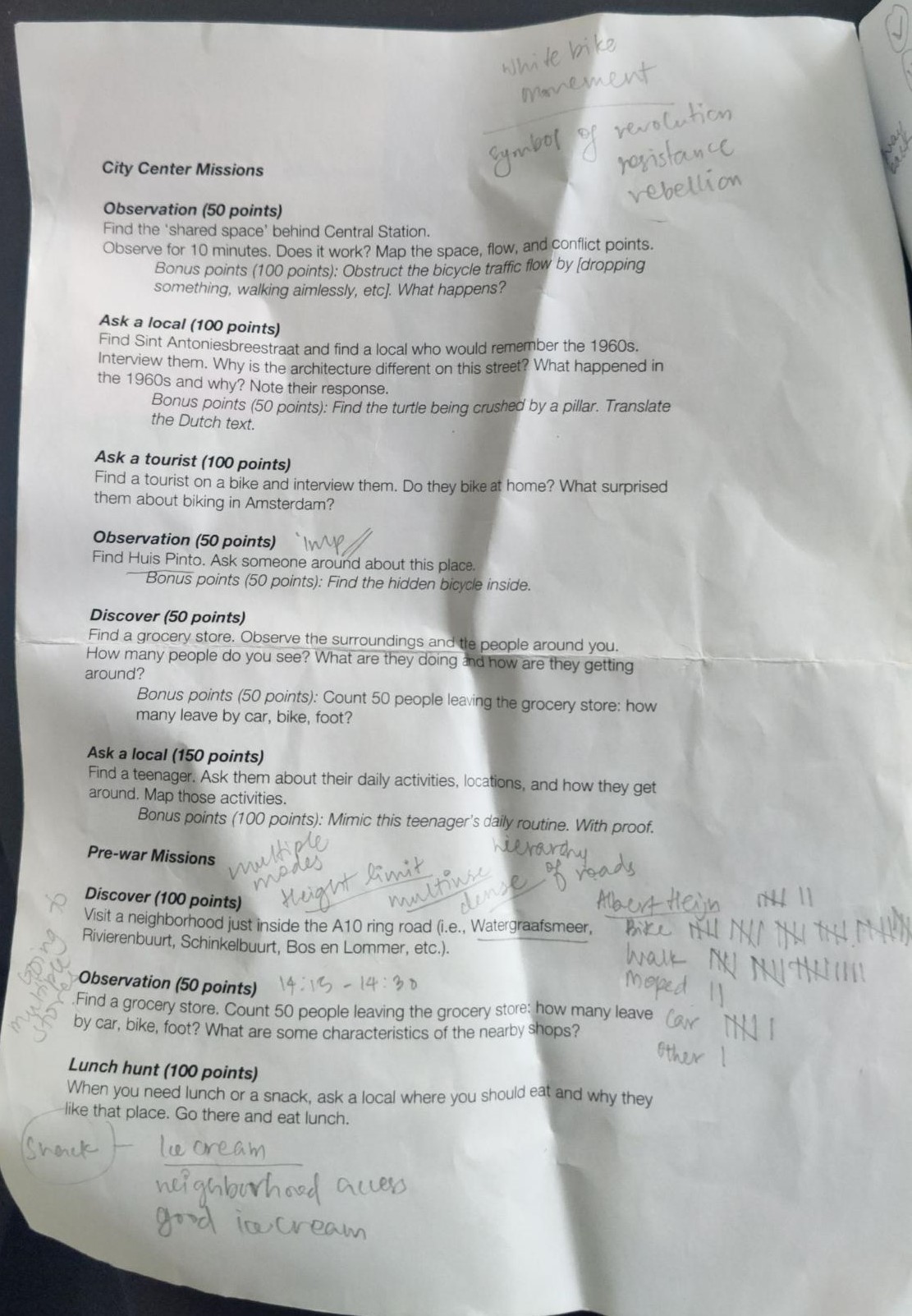
The following two images show my raw field notes and observations.

Things I liked about the activity:
- Structured prompts for observations and tasks. This helped me to collect and organize my thoughts and pay attention to details.
- I loved counting how people traveled in the neighborhoods and comparing them
- I liked learning more about the neighborhoods through these tasks.
- I enjoyed talking to an old man about what I was doing and asking him about his favorite ice cream place.
While I don't have much for improving this scavenger hunt, I would strongly suggest having a map of the city and the neighborhoods before starting out. I wish I was smart enough about the time and got to all the city center tasks.
One of the most important things I took away from this activity was how the city focused on transit-oriented development. The bike network is well connected and maintained. There are multiple options or 'choices' for people to get to places.
 |
| Transit network in Amsterdam |
 |
| Post-war Neighborhood |
 |
| Jumbo next to Gein Metro Station |
 |
| Little Library in the neighborhood |
 |
| Bike path network passing through residential blocks, parks and transit station |

 |
| Pre-war neighborhood park |
 |
| Pre-war neighborhood - Watergraafsmeer |
 |
| Popular ice cream place in the neighborhood |
o What did you learn about Amsterdam in completing this activity? How did the social and spatial factors differ v. cities in the U.S?
This activity helped me understand the urban fabric of the city better. Observing pre- and post- war neighborhoods it was clear that each neighborhood boasts its own distinct character and charm with a unique variety of shops, restaurants, cafes, and attractions. It was enchanting to see how the city grew with each ring and it can be seen in the most subtlest and loudest of ways. Most of the buildings in the pre-war area are made of brick and sturdy construction techniques, whereas the post-war buildings are made of modern materials and quicker construction. The post-war neighborhoods were designed and developed to accommodate booming post-war housing needs.
Deliberate decisions regarding equal access to green spaces are visible throughout the city. The urban fabric is designed to be an activity maximizer, this means the neighborhoods are designed in a way that attracts people to spend more time outside. The incorporation of green spaces through a concept known as the “finger city” was more widely applied to make public park spaces more accessible, and over 800 small neighborhood parks exist throughout the city. Industries are situated in the city’s outskirts whenever possible in an effort to improve livability and maintain separation between living and working areas.
Read more about Amsterdam Urban Policies here:
After World War II, both Europe and America were faced with housing shortage and an upsurge in automobiles. They made room in their cities for free automobile movement. In US there was often so much space available that cities would simply expand into it based on growth.This collective mindset of growing into more open spaces resulted in sprawls which has become a huge issue today. In European countries there was a lack of so much open space and they focused on redefining their urban space. Sprawl was deemed to ruin the open countryside. They had defined walkable streets and courtyards as part of their older cities' urban form. US by then was selling on the promise of a freestanding house for everybody with impressive city skylines in the distant background. By 1980s European and US cities diverged into two alternate futures based on what and who they wanted to focus on.
Today the difference is loudly visible. European cities like Amsterdam began a restorative process that resulted in urban places that are much loved and admired today. In contrast, US cities have an evergrowing list of problems like houselessness, climate displacement, rent escalation, congestion, increasing carbon footprints, each struggling to find a separate solution. US cities focus on urban development that perpetuates the use of automobiles which is a great factor for climate change. Meanwhile in cities like Copenhagen and Amsterdam, they have build a strong pedestrian and cycle network which is safe and reliable. The public transit strengthens the system further and plugs in the rest of the gaps.
As I biked through these neighborhoods I saw a stronger sense of community, denser living conditions and a desire to strive towards improving the collective quality of life. Often, I find that missing in US cities I have been to. Car culture was also prominent in Amsterdam and other European cities. But they deliberately and incrementally restrained, redesigned and reduced. Planning and building codes were rewritten and adapted to make space for people living there and to improve their quality of life.
Right now we desperately need mobility choices in US cities and bring about a change in the way they think about travel.
Comments
Post a Comment